THE JERUSALEM MASTER PLAN
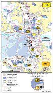
Map Details
The first version of the current Jerusalem Master Plan 2000 was commissioned in 1999 and announced to
the public on 13 September 2004 by then mayor of Jerusalem Uri Lupolianski as the United Jerusalem
Town Planning Scheme (TPS 2000), which would serve as a mandatory map for land use and a blueprint
for other municipal planning purposes up to 2020. The Master Plan was the first planning framework that
included the municipal land of both East and West Jerusalem and treated the city as one urban unit under
Israeli sovereignty. For over a decade, dozens of architects had worked to draw up the plan, meant to
replace the one in effect since 1959 - Master Plan 62, which applies only to the west of the city.
As with all planning in Jerusalem, the premise of the new plan was demographically motivated. One of its
stated objectives was “preserving the Jewish majority in the city of Jerusalem while providing a response to
the needs of the Arab minority residing in the city”. Among its underlying presumptions is a city population
made up of 70% Jews and 30% Palestinians and an anticipated population by 2020 of 950,000 (Palestinians:
38%, Israelis: 62%), despite some predictions that forecast Jewish and Arab populations of equal
size in the city by 2030. The plan expressed concern that “the continued relative growth of the Arab
population in Jerusalem can diminish the proportion of the Jewish population in the future” and suggested
"massive governmental intervention" to counter the current trend.
While expansion of the total area of municipal Jerusalem (at present 126,000 dunums) is foreseen only
westwards, accompanying measures will involve further confiscation of Palestinian land, hamper Palestinian
development, further fragment and isolate Palestinian suburbs from each other as well as from the West Bank,
and weaken the possibility of East Jerusalem becoming the capital for the future Palestinian state.
The plan's initial target date was 2020, but in a May 2009 update 2030 was set as the new goal. The master
plan does not take demographic projections into consideration and vastly underestimates the construction
needs of Jerusalem’s Arab population. It describes only 13,500 new residential units for Palestinians, which
according to recent studies is way below the estimated housing demands of 70,000-90,000 residential units
for the Arab population - expected to reach between 400,000 and 500,000 by 2030. In addition, the vast
majority of housing and development plans for East Jerusalem are foreseen in the outlying northern (Beit
Hanina) and southern neighborhoods (Jabal Mukabber/Arab As-Sawahreh), while restricting development
within the area of central/historic Jerusalem (the Holy Basin), where Israeli development is accelerated.
The master plan fails to propose any new industrial, commercial, service or development areas in East
Jerusalem and plans to eradicate the Wadi Al-Joz industrial area and designate a large track of land between
Jabal Mukabber and Ath-Thori as “a nature reserve”, thus precluding future development of these areas. The
plan’s implications for Arab East Jerusalem have also been criticized for the following provisions:
• The neighborhood plans are small and concentrate on the peripheral northern and southern Palestinian
neighborhoods, widely ignoring Palestinian land ownership in central East Jerusalem.
• The areas designated for planning and building are small and restricted to an area where construction has
already taken place.
• A large area is designated as open landscape, which is not in line with the needs of an urban residential
area.
• In most of the plans, no more than two floors are allowed, severely restricting building rights.
• The lack of roads prevents the laying of statutory infrastructure and hence, the development of the plots.
• Spaces for public buildings are scarce and inadequate and almost uniquely for educational purposes.
• In many cases, only general outline plans have been prepared, for which building permits cannot be issued.
The 2004 plan allocated some 11.8 km2 for new development of Jerusalem neighborhoods (only 2.3 km2 in
Palestinian neighborhoods). The plan was ratified in 2007 by the Jerusalem Municipality’s Planning and
Construction Committee and handed over to the District Committee on 30 April 2007, which began a series
of intense discussions on 8 May 2007. On 7 October 2008, the plan was deposited for public review;
comments by Committee members and newly-elected West Jerusalem Mayor Nir Barkat were discussed in
May 2009, resulting in the District Committee ordering several changes. The updated version, drafted by a
31-member steering committee of planners, geographers and architects is also referred to as Master Plan
2030 as the target date was extended by 10 years. After 2009, there were no further discussions on the
plan. The plan has not been approved and validated to date and has no statutory standing.
The Jerusalem Master Plan is “the manifestation of the Israeli occupation authorities’ political aspirations for
Jerusalem through urban planning” and ignores Palestinian planning needs while consolidating “the Jewish
population’s unlawful presence within occupied East Jerusalem.”
Related Maps
ISRAEL'S SEPARATION BARRIER, 2002
REVISED ROUTE OF THE ISRAELI SEPARATION BARRIER, 2006
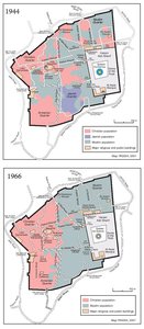
THE OLD CITY, 1944 & 1966
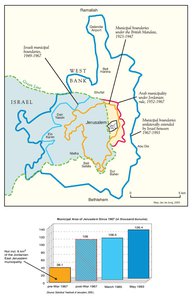
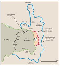
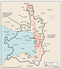
MUNICIPAL BOUNDARIES OF JERUSALEM, 1947-2000
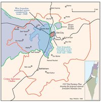
JERUSALEM AND THE CORPUS SEPARATUM PROPOSED IN 1947
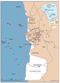
PARTITIONED JERUSALEM, 1948-1967
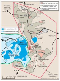
THE KENDALL TOWN SCHEME, 1966
JERUSALEM AFTER THE 1967 WAR
ISRAELI SETTLEMENTS AND PALESTINIAN NEIGHBORHOODS IN EAST JERUSALEM, 2000
ISRAELI SETTLEMENTS AND PALESTINIAN NEIGHBORHOODS IN METROPOLITAN JERUSALEM, 2000
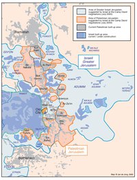
ARAB EAST JERUSALEM WITHIN ‘GREATER’ JERUSALEM, 2000
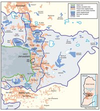
PROJECTION OF THE ISRAELI PROPOSAL FOR JERUSALEM’S FINAL STATUS AT CAMP DAVID, JULY 2000
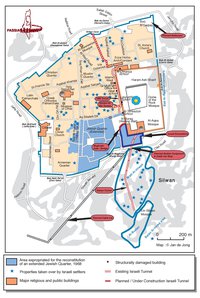
SETTLEMENT ACTIVITY IN THE OLD CITY
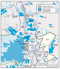
THE E-1 DEVELOPMENT PLAN
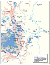
JERUSALEM TODAY (2014)