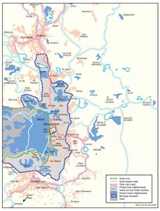
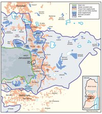
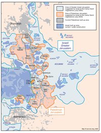
ISRAELI SETTLEMENTS AND PALESTINIAN NEIGHBORHOODS IN METROPOLITAN JERUSALEM, 2000
Map Details
The ‘inner ring’ settlements, and those of the ‘outer ring’ lying beyond the city’s perimeter not only shore up
Palestinian growth almost completely, but function as a bridge between the militarily administered West
Bank hinterland and Israel. Beyond the city limits, the ‘outer ring’s’ industrial zones, bypass network and
vast expropriated land reserves stretch north, south and east – deep into the West Bank.
Consolidation of the ‘outer ring’ – anchored by the sites of Givat Ze’ev, Ma’ale Adumim and the Etzion Bloc
– has been a development priority of all Israeli governments since the early 1980s. These urban centers
have been expanded greatly since that time, to become the service-delivery hubs upon which the smaller
and otherwise less accessible sites deeper in the West Bank depend. The ‘satellite’ sites directly serviced
by the ‘outer ring’s’ infrastructure reach from the eastern hills overlooking the Jordan Valley (Mitzpe
Yericho), north to the hill line beyond Ramallah (Bet El), and south beyond Bethlehem’s southern borders
(Efrata and the Etzion sites). Israel considers this expanse to be the ‘Jerusalem Metropolitan area.’
Combined, the ‘inner ring’ (municipal) settlements and those of the ‘outer ring’ now house well over 250,000
settlers, meaning more Israelis live in these sites than do in West Jerusalem. This demographic swing to
the east and the parallel advances in industrial facilities, make the settlement network in and to the east of
the city, Jewish Jerusalem’s primary growth area and hence the optimal point of contact for the other West
Bank settlements lying beyond. The ‘outer circle’ currently boasts three large industrial parks and a web of
communication lines bringing at least 15 distant sites into close proximity with what is highest priority Israeli
development zone.
In 1994, Prime Minister Rabin invited an Inter-Ministerial Committee to create a formal planning strategy for
this wider area. The following year a Metropolitan Master Plan was unveiled, charting a long-term vision
spreading over a 440-km2 area, made up mostly of West Bank lands beyond the city. This plan, though
later challenged and in itself only new in terms of its formal status, has paved the way for subsequent
expansionism along the lines of a ‘Greater Jerusalem’ area, and opened the floodgates for settlement
activity in the area in question.
Constraints placed by this metropolitan settlement network have suffocated Palestinian villages beyond the
city’s municipal borders in all directions by severing their contact with much of the remainder of the West
Bank and robbing them of their scant land resources. To the north, the city of Ramallah has been bound
along its eastern side by a corridor of fast-developing settlements leading through Kokhav Ya’acov, Psagot
and Bet El, to Ofra, which in turn now serves as metropolitan Jerusalem’s settlement ‘gateway’ to the
northern West Bank sites. In the south, Bethlehem has been flanked by two major bypass arteries linking
the ‘inner ring’ to its north with the Etzion bloc and with the small sites of the southern Bethlehem area. The
eastern hills have been nearly totally depopulated of their non-Jewish population, including the Jahalin
Bedouins, whose forceful expulsion from their homes around the expanding Ma’ale Adumim site began in
the early 1980s. The Jahalin – originally expelled from Israel’s Negev region in the mid-1950s, have since
been relocated (in 1997) to a site 500 m away from Israel’s municipal garbage dump, where they remain
deprived of even the most basic sanitary services, as Ma’ale Adumim consumes their lost grazing
pastures. The cleared eastern metropolitan area now runs from the municipal border all the way to the
Jordan Valley.
The benefits given the outlying remote settlements of the central and northern West Bank by this
metropolitan development are vital to their own growth and expansion. Sites far north of Ramallah or south
of Bethlehem, now boast short journey times to high-capacity medical, educational and economic services,
via the latest in government-sponsored bypass highways. Absorption programs aimed at attracting
immigrants or Israeli migrants to some of the most remote West Bank settlements, which were previously
limited to a small ideological pool of radical messianic Zionists, can now be seen to offer prospective
settlers “housing solutions at reasonable prices… short distances from the big cities…”
Again, the situation is inverted with regard to the Palestinians, whose denial of access to Jerusalem,
including its holy sites, is extended to cover an enormous area of the West Bank and places their
movement both towards and around the city’s municipal area at the discretion of the Israeli forces manning
the myriad checkpoints and blockades that reinforce the metropolitan settlement web. Palestinian travel
between the West Bank’s northern and southern segments is now either circuitous and time consuming or
altogether impossible, while settlers may move rapidly and freely through and around the entire area.
Among the long-term effects of this isolation of Jerusalem from the remainder of the West Bank and the
asphyxiation of its outlying villages has been the collapse of Jerusalem as the economic center of
Palestine (a role since played by Ramallah).
Related Maps
ISRAEL'S SEPARATION BARRIER, 2002
REVISED ROUTE OF THE ISRAELI SEPARATION BARRIER, 2006
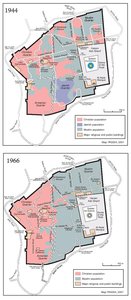
THE OLD CITY, 1944 & 1966
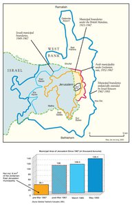
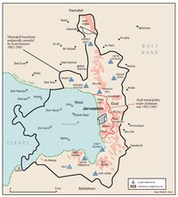
MUNICIPAL BOUNDARIES OF JERUSALEM, 1947-2000
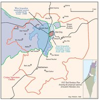
JERUSALEM AND THE CORPUS SEPARATUM PROPOSED IN 1947
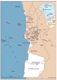
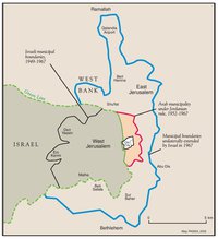
PARTITIONED JERUSALEM, 1948-1967
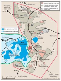
THE KENDALL TOWN SCHEME, 1966
JERUSALEM AFTER THE 1967 WAR
ISRAELI SETTLEMENTS AND PALESTINIAN NEIGHBORHOODS IN EAST JERUSALEM, 2000
ARAB EAST JERUSALEM WITHIN ‘GREATER’ JERUSALEM, 2000
PROJECTION OF THE ISRAELI PROPOSAL FOR JERUSALEM’S FINAL STATUS AT CAMP DAVID, JULY 2000
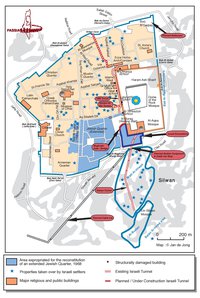
SETTLEMENT ACTIVITY IN THE OLD CITY
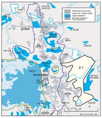
THE E-1 DEVELOPMENT PLAN
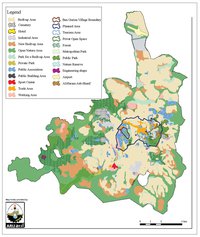
THE JERUSALEM MASTER PLAN
JERUSALEM TODAY (2014)