MUNICIPAL BOUNDARIES OF JERUSALEM, 1947-2000
Map Details
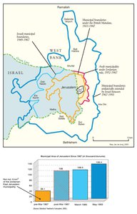
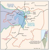
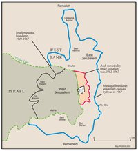
At the close of the Mandate, Jerusalem’s municipal area was 19.2 km2. Following the partition, Israel’s
(West) Jerusalem Municipality (WJM) expanded its 16.26 km2 share of this area to the west. The resulting
West Jerusalem area totaled 38 km2 and incorporated most of the developing Jewish suburbs and many of
the depopulated Palestinian villages in the surrounding hills. In the east, the Arab Municipality, in 1952,
extended East Jerusalem’s 2.2 km2 area to the surrounding villages and suburbs to total an area of 6 km2.
Other plans to expand Jordanian-ruled East Jerusalem’s boundaries to the northern suburbs, where the
most intense urban development was centered, were never implemented.
After the 1967 War, Israel redefined Jerusalem’s municipal limits dramatically before absorbing the entire
expanded area within the State of Israel, in total disregard for international opinion and in flagrant violation
of international laws prohibiting the acquisition of territory by force. Official annexation followed 13 years
later, on 30 July 1980, when the Knesset formalized the illegally expanded municipal limits and declared the
entire area inseparable from the state of Israel. The new municipal limits carved an additional 64 km2 out of
the West Bank, being the lands of 28 Palestinian villages and large portions of the municipal areas of
Ramallah, Al-Bireh and Bethlehem. However, in drawing these lines, an Israeli committee carefully limited
the inclusion of Palestinian built-up areas so as to reduce the demographic weight of the ‘non-Jews’
absorbed in the city. The new boundaries were guided by the desire to control the key defensive hilltops,
communication lines and valleys, and by the decision, “not to include too many Arab residents in the
annexed area, and to include open areas for the development of Jewish neighborhoods [settlements].”
The hugely expanded area – being a ten-fold increase on East Jerusalem’s pre-1967 size – incorporated
merely 22,000 additional Palestinians. A further 44,000 resided in the 10% of the annexed area that lay
within pre-1967 East Jerusalem municipal borders. The expansion, formally approved by Israel’s Cabinet
on 26 July 1967, and by the Knesset two days later, brought the entire (East and West) Jerusalem municipal
area to a total of 108 km2. Following the expulsions from the Old City , the population ratio
in this area stood at 74.2% Jewish: 25.8% Palestinian. A total of 266,300 people lived within the city limits.
Faced with a high growth rate in the Palestinian population, and the priority of maintaining a substantial majority
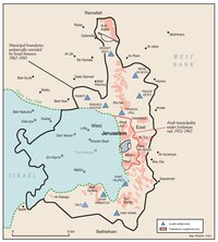
in the city, Israel’s Jerusalem policy focused on the rapid construction of settlements in the annexed
east and the absorption of a maximum number of Jewish migrants and immigrants in the city. Between
1967 and 1985, 10 large urban settlements were established on confiscated land in occupied East Jerusalem.
By 1983, over 50,000 Jews were living in East Jerusalem settlements and by 1985, the Jewish population
in Jerusalem had reached 328,000. Nonetheless, high Palestinian population growth countered the
demography of the settlers and the 1985 Jewish-Arab ratio even evinced a slight decline in the Jewish
relative majority (71.6%:28.4%).
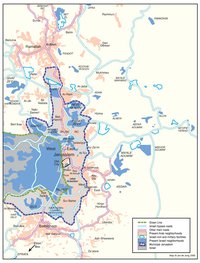
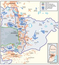
In 1985, and again in 1993, the municipal boundaries were redrawn with the sole purpose of controlling this
demographic trend. This time the city stretched westward – by 0.5 km2 in 1985 and by 17.9 km2 in 1993 –
bringing Jerusalem’s municipal area to its current 126.4 km2 area. About 51% of this area is made up of
annexed Palestinian West Bank land beyond the pre-1967 East Jerusalem municipal boundaries, 5% is
made up of the original East Jerusalem municipal area, 30% corresponds to the pre-1967 West Jerusalem
area, and the remaining 14% has been annexed to the west since 1985.
Through much of the 1980s, Jewish growth rates in the city were in fact negative, and in the 1990s they
rarely exceeded 1.3% annually, while the Palestinian growth rate has consistently been around three times
this figure. By expanding the city west to incorporate Jewish satellite suburbs, Israel was able to only
partially slow the inevitable natural erosion of its demographic majority. By 1998, of the city’s 633,700
inhabitants, 68.4% were Jewish and 31.6% Palestinian; the Jewish growth rate stood at 1% per annum, the
Palestinian rate at 3.5%. This natural factor, more than any other, has spurred Israel’s massive settlement
program in East Jerusalem and guided its discriminatory policies aimed at encouraging, if not forcing,
Palestinians from the city.
Related Maps
ISRAEL'S SEPARATION BARRIER, 2002
REVISED ROUTE OF THE ISRAELI SEPARATION BARRIER, 2006
THE OLD CITY, 1944 & 1966
JERUSALEM AND THE CORPUS SEPARATUM PROPOSED IN 1947
PARTITIONED JERUSALEM, 1948-1967
THE KENDALL TOWN SCHEME, 1966
JERUSALEM AFTER THE 1967 WAR
ISRAELI SETTLEMENTS AND PALESTINIAN NEIGHBORHOODS IN EAST JERUSALEM, 2000
ISRAELI SETTLEMENTS AND PALESTINIAN NEIGHBORHOODS IN METROPOLITAN JERUSALEM, 2000
ARAB EAST JERUSALEM WITHIN ‘GREATER’ JERUSALEM, 2000
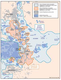
PROJECTION OF THE ISRAELI PROPOSAL FOR JERUSALEM’S FINAL STATUS AT CAMP DAVID, JULY 2000
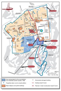
SETTLEMENT ACTIVITY IN THE OLD CITY
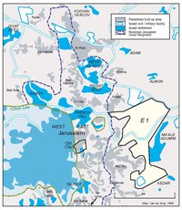
THE E-1 DEVELOPMENT PLAN
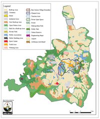
THE JERUSALEM MASTER PLAN
JERUSALEM TODAY (2014)
