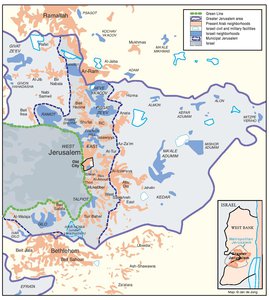
ARAB EAST JERUSALEM WITHIN ‘GREATER’ JERUSALEM, 2000
Map Details
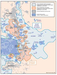
As noted, the current 126 km2 of municipal Jerusalem do not represent Israel’s complete vision of the city
but rather an ‘interim’ stage in the long-term goal of achieving so-called ‘Greater Jerusalem.’ The concept
was broached by the original 1967 WJM, which set itself the target of creating “the largest Jewish city in the
world… both in terms of population and in giving a permanent Jewish character to the whole city.” The idea
calls for a greatly expanded and annexed city area containing a maximum of Jews and a minimum of Palestinians.
It found expression in the original 1967 Allon Plan, which advocated the creation of
a broad annexed strip, ”from the north of the traffic axis between Jerusalem and the Dead Sea [today’s Adumim
area], to be connected with… the Latrun region [between West Jerusalem and Tel Aviv].” This broad
definition was given more solidity in the 1973 Labor settlement guidelines of Israel Galili, who prescribed
“increasing the population of Jerusalem and its industrial development… beyond the area defined by
Administrative Order No. 1 [municipal Jerusalem].” Galili’s document resolved that ”attempts will be made to
acquire supplementary… lands to the east and south of the city.”
In keeping with much of Israel’s early settlement planning, these fundamental policy documents avoided
specifics in their recommendations so as to grant the politicians and military strategists flexibility. Suitable
sites were simply selected by the Defense Minister and Settlement Committee and the task of creating
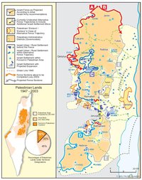
‘Greater Jerusalem’ begun on the ground. Only in 1983 did the Israeli government define the preliminary
boundaries of ‘Greater Jerusalem’ in any detail. That plan stretched beyond Ramallah to the north, reached
Jericho in the east, Bet Shemesh and Latrun to the west and Bethlehem in the south. The huge mapped area
served as the guide for developing the long-term Jewish majority considered the prerequisite for ultimate
annexation of ‘Greater Jerusalem’ to Israel. Between 1983-1992, 71% of all OPT settlement construction
occurred in this area.
In 1993, a new team of government planners and economists was charged by Prime Minister Rabin with
redefining ‘Greater Jerusalem’ - a move made in response to the perceived challenge to Israel’s Jerusalem
aims posed by the emerging peace talks. The plan revised and reduced the original area to one of
approximately 260 km2, leaving Bethlehem and Ramallah beyond its limits but otherwise loosely following
the east-west delineations offered in the previous plan. Approval of the 1993 ‘Greater Jerusalem’ scheme
was again coupled with heavy investment towards securing Jewish dominance therein. A new settlement
‘neighborhood’ of 1,950 units was immediately authorized to strengthen the Ma’ale Adumim site and a
series of roads and tunnels planned to link this site with Givat Ze’ev in the northwest (this second project
crystallized within the E1 Development Plan). In the south, a $42 million bypass route of
tunnels and bridges, linking the ‘inner ring’ settlements of Gilo and East Talpiot with the 14 Etzion Bloc
settlements was started. The estimated area of the 1993 Labor government’s vision of ‘Greater Jerusalem’
is that shown on the map opposite. If this area is taken to define ‘Greater Jerusalem,’ Israel may have
succeeded in creating its Jewish majority, if not definitively, even by 1992 – when 445,800 Jews and ca.
400,000 Palestinians were estimated resident in the area.
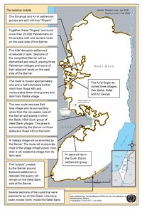
In 1997, Netanyahu’s Likud government turned to the ‘Greater Jerusalem’ plan with zeal, in part to regain
the endorsement of those hard-line supporters critical of its handling of the January 1997 Hebron Protocol. A month after the partial redeployment in Hebron, Netanyahu declared, “the battle in Jerusalem
has begun,” as land clearing was commenced on the delayed Har Homa settlement site. As part of a
wider plan for annexing 60% of the West Bank, he presented the government with a new version of ‘Greater
Jerusalem.’ The new plan envisioned a return to the 1983 maximal lines, reaching settlements beyond the
1993 limits, such as Bet El and Psagot to the northeast of Ramallah. As well as creating expanded future
annexation lines, the plan created – initially in secret – an ‘umbrella municipality’ for the ‘Greater Jerusalem’
area, charged with, “the integration of the settlements to the east, north and south, especially regarding
planning and construction.” In effect, the ‘umbrella’ plan was only a scheme for streamlining existing planning
mechanisms, which had long been guided by similar objectives. However, the attempt to render de jure
a de facto union of Israel’s military occupation authorities with its municipal authorities created upset and
UNSC condemnation, forcing the Israeli authorities to sink the ‘umbrella’ beneath a renewed and tightened
veil of silence. Nonetheless, by mid-1998 manifestations of its realization were clear. A new ‘metropolitan’
industrial zone was approved by the WJM beside Az-Za’im village, west of the vast E1 Plan, but beyond the
municipal limits; new master plans for the settlements of Neve Ya’acov (within the municipality) and Adam
(beyond the municipality) showed massive future growth aimed at uniting the two sites fully.
By 2002, over 76,000 settlers lived in the loosely defined ‘Greater Jerusalem’ area lying beyond the municipal
boundaries of East Jerusalem. About 10,000 of these had settled there since 1998. Plans currently exist to
double the number of housing units in the area. When Ehud Barak took office in 1999, it was to this latest
version of ‘Greater Jerusalem’ that he referred his negotiators. The 1997 extended ‘Greater Jerusalem’ was
thus adopted as Israel’s definition of the city for the purpose of the final status talks with the Palestinians.
Related Maps
ISRAEL'S SEPARATION BARRIER, 2002
REVISED ROUTE OF THE ISRAELI SEPARATION BARRIER, 2006
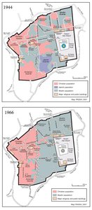
THE OLD CITY, 1944 & 1966
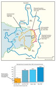
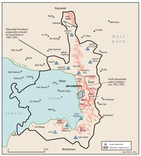
MUNICIPAL BOUNDARIES OF JERUSALEM, 1947-2000
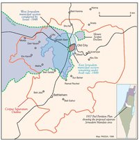
JERUSALEM AND THE CORPUS SEPARATUM PROPOSED IN 1947
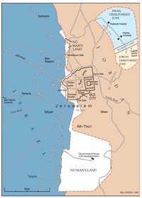
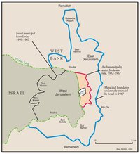
PARTITIONED JERUSALEM, 1948-1967
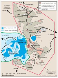
THE KENDALL TOWN SCHEME, 1966
JERUSALEM AFTER THE 1967 WAR
ISRAELI SETTLEMENTS AND PALESTINIAN NEIGHBORHOODS IN EAST JERUSALEM, 2000
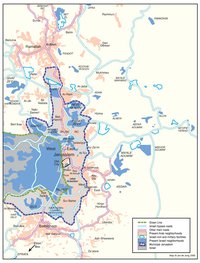
ISRAELI SETTLEMENTS AND PALESTINIAN NEIGHBORHOODS IN METROPOLITAN JERUSALEM, 2000
PROJECTION OF THE ISRAELI PROPOSAL FOR JERUSALEM’S FINAL STATUS AT CAMP DAVID, JULY 2000
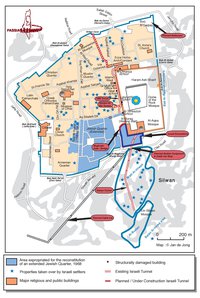
SETTLEMENT ACTIVITY IN THE OLD CITY
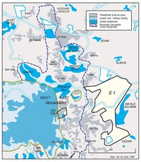
THE E-1 DEVELOPMENT PLAN
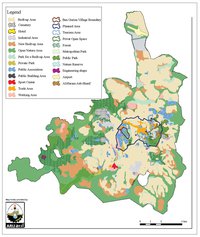
THE JERUSALEM MASTER PLAN
JERUSALEM TODAY (2014)