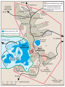
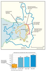
THE KENDALL TOWN SCHEME, 1966
Map Details
The small, partially depopulated and under-developed area making up Arab East Jerusalem following the
1948-49 War and partition of the city provided virtually no prospects for growth. Socio-economic factors
drawing the Palestinian population east to Amman and its surrounds in search of better opportunities
combined with the near-total absence of Mandate-period development in the Palestinian neighborhoods
ringing the Old City, left the Jordanian-ruled city in dire need of a planning scheme to revitalize the city.
However, such a plan was not to be endorsed by the Jordanian government until 1966, when the erosion of
the economic fiber of the city had already become critical.
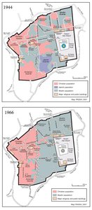
British planner Henry Kendall had worked in the city under the Mandate, drawing up, in 1944, a
comprehensive plan for the city which envisioned reasonably equitable development to both the east and
west of the Old City. His 1944 plan provided for modernization along industrial and urban lines based on the
arterial routes leading west towards the coastal plain as well as those running north-south to serve the
Palestinian markets and towns of what would become the West Bank. The 1944 plan was not implemented
and with the outbreak of the 1947-49 War, its vision of a united and integrated development city ceased to
be relevant.
In 1964, Kendall drew up a scheme to relieve a cramped and debilitated Arab East Jerusalem. Adopted by
the Jordanian government only in 1966, the plan acknowledged the need to extend the city’s boundaries to
incorporate the developing neighborhoods and villages lying along the Ramallah/Nablus-bound (northern)
and Bethlehem/Hebron-bound (southern) routes, as well as to the villages to the immediate east of the city,
through which the highway linking the city with Amman ran. The Kendall Town Plan posited a single urban
development scheme for the population centers lying between Bethlehem and Ramallah, with the Old City
and existing municipal area at its center. Industrial and commercial areas were foreseen, distributed so as
to provide for economic growth while not impinging on the Old City, its environs or the existing lands
sustaining the agricultural economy of outlying villages.
Some 30,000 additional residential units were planned, while substantial areas within and around the city
were to be reserved for later growth or protected as parkland or nature reserves. By placing within the city
limits the airport to the north, as well as a ring of industrial zones, the Kendall Plan not only stood to boost
the flagging economic life of the city, but to return it to its rightful and historic status as the socio-economic
hub of Palestinian life. Direct and immediate development was extended to the limits of the city so as to
place the towns of Bethlehem and Ramallah within the remit of anticipated growth. In this sense, the
scheme took up the challenge of recreating an integrated and cohesive Palestinian development base for
the whole West Bank. Indeed, while the plan incorporated the existing centrality of the Amman link to the
east, it simultaneously presented a distinctly Palestinian view of Jerusalem’s future, acknowledging the
importance of communication lines to the Jordanian capital, while drawing the outlying West Bank economy
and infrastructure back into harmony with the Palestinian capital’s development.
The Kendall Plan was adopted by the Jordanian government on the eve of the Israeli invasion and occupation
of the city and entire West Bank and as such was robbed of its currency almost immediately. With the
unilateral and illegal expansion of the conquered city in 1967, Israel pressed a diametrically opposed vision
of the city upon the Palestinian inhabitants and those of the surrounding villages, robbing them of the
prospects enshrined in the 1966 Plan and instead pursuing an expropriation and settlement program, which
would drastically compound the unsustainable conditions Kendall sought to rectify.
Related Maps
ISRAEL'S SEPARATION BARRIER, 2002
REVISED ROUTE OF THE ISRAELI SEPARATION BARRIER, 2006
THE OLD CITY, 1944 & 1966
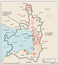
MUNICIPAL BOUNDARIES OF JERUSALEM, 1947-2000
JERUSALEM AND THE CORPUS SEPARATUM PROPOSED IN 1947
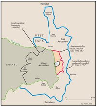
PARTITIONED JERUSALEM, 1948-1967
JERUSALEM AFTER THE 1967 WAR
ISRAELI SETTLEMENTS AND PALESTINIAN NEIGHBORHOODS IN EAST JERUSALEM, 2000
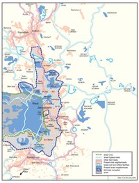
ISRAELI SETTLEMENTS AND PALESTINIAN NEIGHBORHOODS IN METROPOLITAN JERUSALEM, 2000
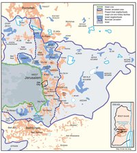
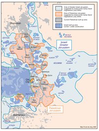
ARAB EAST JERUSALEM WITHIN ‘GREATER’ JERUSALEM, 2000
PROJECTION OF THE ISRAELI PROPOSAL FOR JERUSALEM’S FINAL STATUS AT CAMP DAVID, JULY 2000
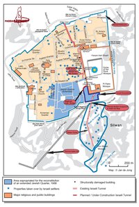
SETTLEMENT ACTIVITY IN THE OLD CITY
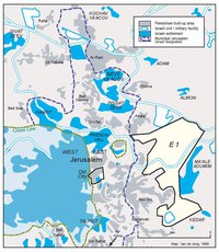
THE E-1 DEVELOPMENT PLAN
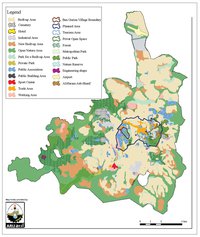
THE JERUSALEM MASTER PLAN
JERUSALEM TODAY (2014)