ADMINISTRATIVE BOUNDARIES
Map Details
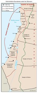
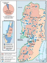
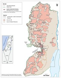
Prior to the British Mandate, Ottoman Palestine was made up of three Sanjaks, or sub-provinces, each ruled by a Mutasarrif (provincial governor). Of these, the Sanjak of Acre and that of Balqa’, or Nablus, fell within the larger Vilayet (province) of Beirut, while the largest, Jerusalem -owing to its religious and historical status- was independent, with its governor responsible directly to the Sultan. The British administered Palestine through a series of 16 sub-districts, each responsible to the High Commissioner in the capital, Jerusalem. These sub-districts were adjusted once, in the late 1930s, but remained operational throughout the Mandate. Following the 1947-1949 War, Jordan administered the West Bank according to similar set of sub-districts, placing the villages surrounding its 11 principal towns under local governors responding to Amman via Jerusalem, which remained the Palestinian capital and was also declared the ‘second capital’ of Jordan. Israel’s occupation in 1967 saw these reasonably organic sub-divisions replaced by a streamlined system of military ruled through seven large governorates, which denied the existence of Palestinian Jerusalem both as a city and as Palestine’s central administrative sub-division. In 1995, the Palestinian Authority adopted new administrative sub-divisions, returning to boundaries more in keeping both with historical fact and local Palestinian socio-economic and cultural factors, forming an 11 governorate system in the West Bank and dividing, for the first time, the populous Gaza Strip into five governorates. Each PA governorate was placed under a local authority which administered both Area A and B through branches of ‘national’ ministerial and welfare services, except in the re-designated Jerusalem governorate, where the lack of an Area A presence limited PA governmental activity.
Related Maps
OTTOMAN PALESTINE, 1878
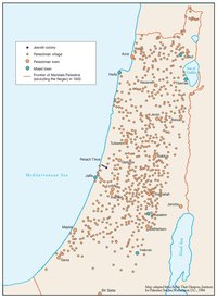
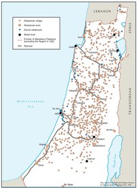
ARAB TOWNS AND JEWISH SETTLEMENTS IN PALESTINE, 1881-1914
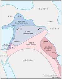
THE SYKES-PICOT AGREEMENT, 1916
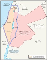
THE BEGINNING OF THE BRITISH MANDATE, 1920
PALESTINE UNDER THE BRITISH MANDATE
THE DEMOGRAPHY OF PALESTINE, 1931
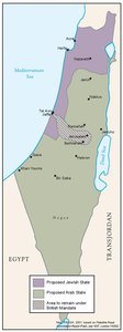
THE PEEL COMMISSION PARTITION PROPOSAL, 1937
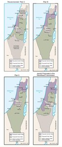
THE WOODHEAD COMMISSION PARTITION PROPOSALS, 1938
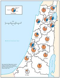
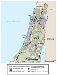
PALESTINIAN AND ZIONIST LANDOWNERSHIP BY SUB-DISTRICT, 1945
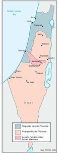
THE MORRISON-GRADY PARTITIONED TRUSTEESHIP PLAN, 1946
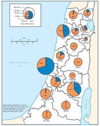
POPULATION OF PALESTINE BY SUB-DISTRICT, 1946
LAND OWNERSHIP IN PALESTINE, 1948
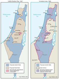
THE UNGA PARTITION PLAN, 1947 – THE 1948 WAR & THE 1949 ARMISTICE LINES
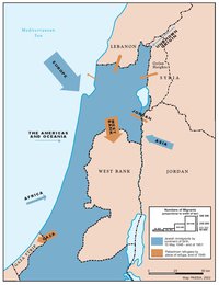
POPULATION MOVEMENTS, 1948-1951
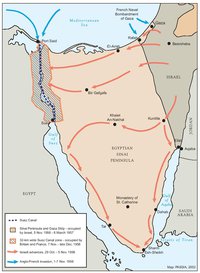
THE SUEZ WAR, 1956
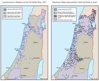
LAND OWNERSHIP IN PALESTINE AND THE UN PARTITION PLAN - PALESTINIAN DEPOPULATED AND DESTROYED VILLAGES, 1948-1949
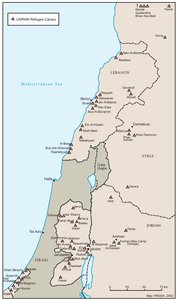
THE PALESTINIAN DIASPORA, 1958
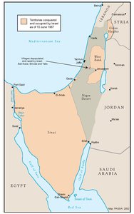
THE NEAR EAST AFTER THE JUNE 1967 WAR
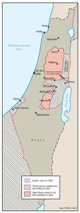
THE ALLON PLAN, JUNE 1967
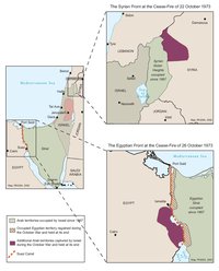
THE OCTOBER WAR, 1973
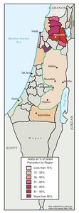
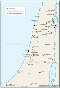
THE PALESTINIANS INSIDE ISRAEL, 1977
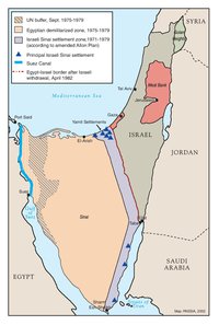
THE CAMP DAVID ACCORDS, 1978-1979
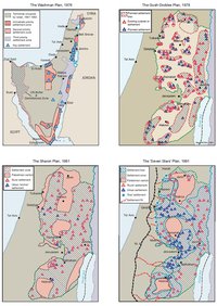
ISRAELI SETTLEMENT MASTER PLANS, 1976-1991
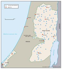
THE 1991 MADRID PEACE CONFERENCE & ISRAELI SETTLEMENTS
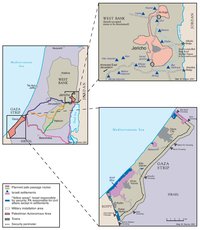
GAZA-JERICHO (OSLO I) AGREEMENT, CAIRO, 4 MAY 1994
INTERIM (OSLO II) AGREEMENT, TABA, 28 SEPTEMBER 1995
HEBRON PROTOCOL, 15 JANUARY 1997
WYE RIVER MEMORANDUM, 23 OCTOBER 1998
SHARM ESH-SHEIKH AGREEMENT, 4 SEPTEMBER 1999
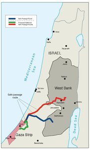
PROTOCOL CONCERNING SAFE PASSAGE BETWEEN THE WEST BANK AND THE GAZA STRIP, 5 OCTOBER 1999
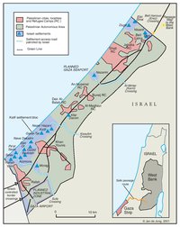
GAZA, 2000
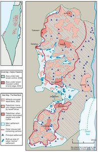
WEST BANK AND GAZA STRIP, MARCH 2000
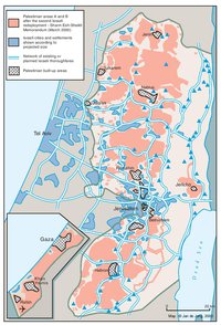
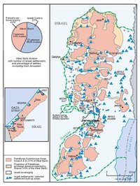
CAMP DAVID PROJECTION, JULY 2000
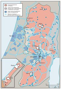
TABA TALKS PROJECTION, JANUARY 2001
THE SHARON PROPOSAL, SPRING 2001
THE REINVASION OF THE PALESTINIAN TERRITORIES, 2001-2002
THE ROAD MAP, 2003

THE GENEVA INITIATIVE AND ACCORD, 2003
THE ISRAELI DISENGAGEMENT PLAN, 2003-2005
AGREED DOCUMENTS ON MOVEMENT AND ACCESS FROM AND TO GAZA, 2005
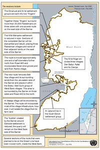
THE SETTLERS' PLAN FOR PALESTINIAN AUTONOMY, 2006
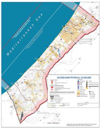
THE GAZA STRIP TODAY (2014)
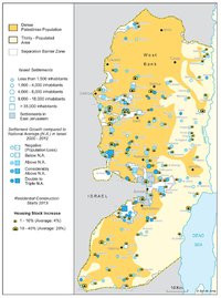
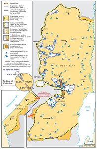
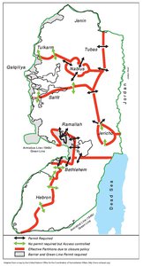
THE WEST BANK TODAY (2014)

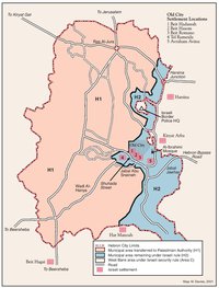
HEBRON
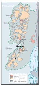
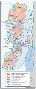
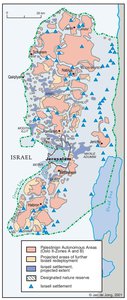
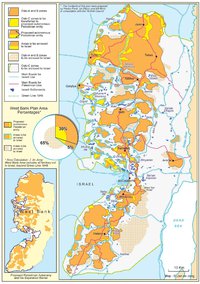
Area C